.jpg)
.jpg)
.jpg)
.jpg)
.jpg)


.jpg)

 Maximize
 Maximize

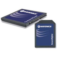
Electronic chart Navionics Platinum Plus XL3.
Choose the area of your choice by clicking here (see bottom of page site Navionics) then enter the reference in the field 'Comments' of the order process.
Navionics charts are established to provide knowledgeable boaters and fishermen a clearer and more readable map with the same essential details as published on paper maps. They provide smooth playback and understanding perfect at every zoom level. Display technology offers a quick, gentle and transition continues from one area to another, regardless of the selected scale.
-Level of uneven quality
-Views 3D, satellite photos and panoramic photos with a finesse and a realism even more striking with a resolution high
-More features
-An abundance of images
-3D bathymetry and land views
-Panoramic photos
-Data on port services
-Information, tides and currents
-Instructions of coastal navigation, geo-referenced
Caution: this product is programmed on command. All committed orders cannot be repeated or modified.