.jpg)
.jpg)
.jpg)
.jpg)
.jpg)


.jpg)

 Maximize
 Maximize

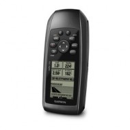
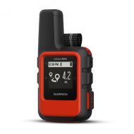
Read your position on a detailed map in any situation on a very bright screen of 41 x 56 mm! Equipped with an electronic compass, an altimeter, an antenna high sensitivity, strong, waterproof and floating, the GPSMAP 78 s is the most versatile unit for use in difficult conditions.
For boaters and watersports enthusiasts who want the best, the GPSMAP 78 s is robust and has a 3-axis electronic compass, barometric altimeter, of a screen map color, a receiver high sensitivity, a box of anti-slip soft rubber and a reader of card microSD™ to load additional cards. In addition, it floats when by misfortune he goes overboard!
Explore The GPSMAP 78 s comes with a world map background integrated to allow you to go anywhere with ease. And as the other devices of the 78, the GPSMAP 78 s series is waterproof according to the standard IPX7 and floats on the surface of the water.
Find your bearings The GPSMAP 78 s is equipped with a 3-axis tilt-compensated electronic compass that displays your heading even when you are stopped or that you do not hold it horizontally. Its barometric altimeter allows you to monitor the weather conditions and anticipate changes in time.
Share wireless With the GPSMAP 78 s, you can share your waypoints, tracks, routes with other users of compatible devices wireless. Now you can send the position of your fishing spot to a friend without leaving your boat.
The heading hold Equipped with a GPS receiver high-sensitivity WAAS-compatible and a HotFix™ system, the GPSMAP 78 shows quickly and precisely your position on the map. Effective, it maintains the signal in difficult conditions (boat cabin, under the trees)
Add maps Add maps with ease thanks to the microSD card port. Located in the battery compartment, your card is protected from spray and sea packages. Use on your charts detailed BlueChart® g2 portable GPS to spend a day at sea and display on-screen information navigation: areas of false, markup, regulated, probe points, wrecks... Also use your GPSMAP 78 s in your car. Ideal for towing your hardtail, the GPSMAP 78 s knows also read road maps CityNavigator NT®.
Prepare your outputs At home, planning your next trip with the HomePort™ route planning software (not supplied). This software allows you to create your routes and/or waypoints to display the profile of the bottom, to calculate the distance and travel time.
GPSMAP 78 s: designed to last and float: everything a sailor needs.